
Make a donation
Gear up for your next adventure:
As an Amazon Associate, this site earns from qualifying purchases at no extra cost to you.
Cervantes topographic map
Click on the map to display elevation.
Make a donation
Gear up for your next adventure:
As an Amazon Associate, this site earns from qualifying purchases at no extra cost to you.
Cervantes
These elevations are located in the nearby mountain ranges of A Trappe, Lóuzara, O Oribio, O Rañadoiro and O Piornal .
Make a donation
Gear up for your next adventure:
As an Amazon Associate, this site earns from qualifying purchases at no extra cost to you.
About this map
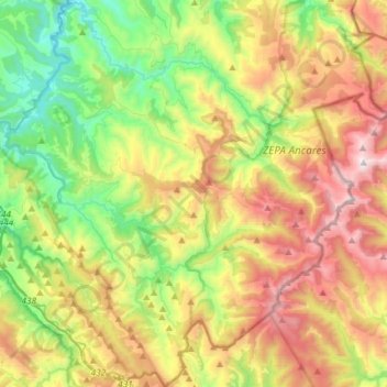
Name: Cervantes topographic map, elevation, terrain.
Location: Cervantes, Os Ancares, Lugo, Galicia, Spain (42.71869 -7.10979 42.93382 -6.83368)
Average elevation: 3,255 ft
Minimum elevation: 1,099 ft
Maximum elevation: 6,473 ft
Make a donation
Gear up for your next adventure:
As an Amazon Associate, this site earns from qualifying purchases at no extra cost to you.
Other topographic maps
Click on a map to view its topography, its elevation and its terrain.