
Make a donation
Gear up for your next adventure:
As an Amazon Associate, this site earns from qualifying purchases at no extra cost to you.
Height topographic map
Click on the map to display elevation.
Make a donation
Gear up for your next adventure:
As an Amazon Associate, this site earns from qualifying purchases at no extra cost to you.
About this map
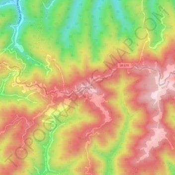
Name: Height topographic map, elevation, terrain.
Location: Height, Buchanan County, Virginia, 24850, United States (37.26067 -81.83400 37.30067 -81.79400)
Average elevation: 2,379 ft
Minimum elevation: 1,624 ft
Maximum elevation: 2,940 ft
Buchanan County trails, hiking, mountain biking, running and outdoor activities
Make a donation
Gear up for your next adventure:
As an Amazon Associate, this site earns from qualifying purchases at no extra cost to you.
Other topographic maps
Click on a map to view its topography, its elevation and its terrain.
Breaks Interstate Park
United States > Virginia > Buchanan County > Conaway
Average elevation: 1,565 ft