
Thank you for supporting this site ❤️
Make a donation
Make a donation
Gear up for your next adventure:
As an Amazon Associate, this site earns from qualifying purchases at no extra cost to you.
Circasia topographic map
Click on the map to display elevation.
Thank you for supporting this site ❤️
Make a donation
Make a donation
Gear up for your next adventure:
As an Amazon Associate, this site earns from qualifying purchases at no extra cost to you.
About this map
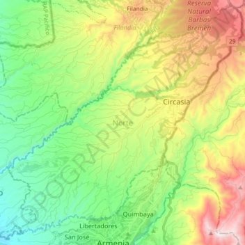
Name: Circasia topographic map, elevation, terrain.
Location: Circasia, Norte, Quindío, 631001, Colombia (4.53813 -75.74046 4.68467 -75.59560)
Average elevation: 5,440 ft
Minimum elevation: 4,062 ft
Maximum elevation: 7,667 ft
Thank you for supporting this site ❤️
Make a donation
Make a donation
Gear up for your next adventure:
As an Amazon Associate, this site earns from qualifying purchases at no extra cost to you.