Geolocate

Norfolk topographic map

Click on the map to display elevation.

About this map

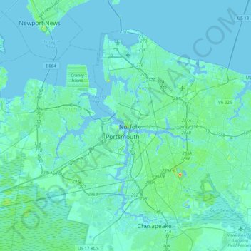
Name: Norfolk topographic map, elevation, terrain.

Location: Norfolk, Virginia, 23510, United States of America (36.68629 -76.45293 37.00629 -76.13293)

Average elevation: 13 ft

Minimum elevation: -23 ft

Maximum elevation: 138 ft

Gear up for your next adventure:

🛏️Cold Weather Sleeping Bag - Warm sleeping bag for cold conditions
🌡️Portable Weather Meter - Track weather conditions on the trail
🔭Stargazing Telescopes - Perfect for camping in low-light pollution areas shown on maps
🏕️Tent Footprint - Protect your tent base from wear
💧Water Filtration Bottles - Safely drink from streams and lakes while exploring

As an Amazon Associate, this site earns from qualifying purchases at no extra cost to you.