Geolocate

Nether Heyford topographic map

Click on the map to display elevation.

About this map

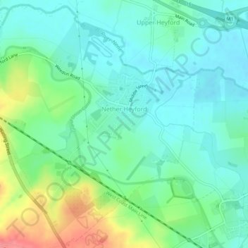
Name: Nether Heyford topographic map, elevation, terrain.

Location: Nether Heyford, West Northamptonshire, England, United Kingdom (52.20554 -1.06605 52.23206 -1.02156)

Average elevation: 299 ft

Minimum elevation: 226 ft

Maximum elevation: 479 ft

Other topographic maps

Click on a map to view its topography, its elevation and its terrain.

Gear up for your next adventure:

🗃️Trail First Aid Kit - Essential kit for outdoor injuries and emergencies
🏕️Tent Footprint - Protect your tent base from wear
🎒Trekking Poles - Sturdy poles for balance and stability on rough terrain
🔭Telescopic Hiking Pole - Adjustable pole for hiking stability
🛏️Cold Weather Sleeping Bag - Warm sleeping bag for cold conditions

As an Amazon Associate, this site earns from qualifying purchases at no extra cost to you.