Geolocate

Ponferrada topographic map

Click on the map to display elevation.

About this map
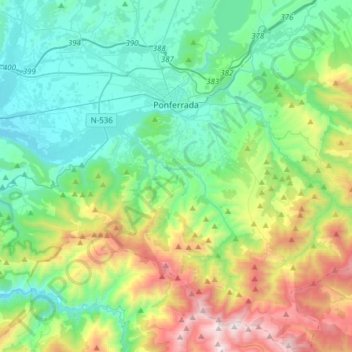
Name: Ponferrada topographic map, elevation, terrain.

Location: Ponferrada, El Bierzo, León, Castile and León, Spain (42.38622 -6.71411 42.61270 -6.40717)

Average elevation: 2,897 ft

Minimum elevation: 1,391 ft

Maximum elevation: 7,008 ft

Other topographic maps

Click on a map to view its topography, its elevation and its terrain.
A Corona

Spain > Castile and León > El Bierzo > Candín

Average elevation: 3,232 ft

Gear up for your next adventure:

🪶LED Camping Lantern - Bright lantern for camp lighting
🗺️Topographic Maps - Detailed topo maps for hiking, exploring and outdoor navigation
📶Satellite Messenger - Communication device off‑grid
🌎3D Topographic Globes - Raised relief globes for a tactile understanding of geography
🪄Magnetic Compass - Accurate compass for navigation

As an Amazon Associate, this site earns from qualifying purchases at no extra cost to you.