
Vista Hermosa topographic map
Interactive map
Click on the map to display elevation.
About this map
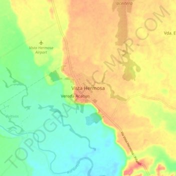
Name: Vista Hermosa topographic map, elevation, terrain.
Location: Vista Hermosa, Ariari, Meta, Colombia (3.08598 -73.78972 3.16598 -73.70972)
Average elevation: 902 ft
Minimum elevation: 784 ft
Maximum elevation: 1,033 ft
Other topographic maps
Click on a map to view its topography, its elevation and its terrain.
Caño Amarillo
Colombia > Meta > Vista Hermosa
Caño Amarillo, Vista Hermosa, Ariari, Meta, RAP (Especial) Central, Colombia
Average elevation: 997 ft
Tercer Milenio
Colombia > Meta > Vista Hermosa
Tercer Milenio, Vista Hermosa, Ariari, Meta, Colombia
Average elevation: 692 ft