
Göksu Mahallesi topographic map
Interactive map
Click on the map to display elevation.
About this map
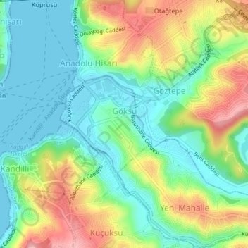
Name: Göksu Mahallesi topographic map, elevation, terrain.
Location: Göksu Mahallesi, Beykoz, Istanbul, Marmara Region, Turkey (41.07211 29.06425 41.08274 29.07756)
Average elevation: 157 ft
Minimum elevation: -3 ft
Maximum elevation: 430 ft
Other topographic maps
Click on a map to view its topography, its elevation and its terrain.
Paşabahçe Mahallesi
Paşabahçe Mahallesi, Beykoz, Istanbul, Marmara Region, Turkey
Average elevation: 125 ft
Yalıköy Mahallesi
Yalıköy Mahallesi, Beykoz, Istanbul, Marmara Region, Turkey
Average elevation: 102 ft