
Ghaghara River topographic map
Interactive map
Click on the map to display elevation.
About this map
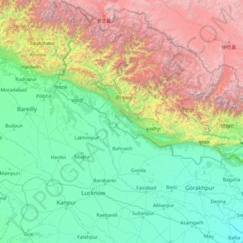
Name: Ghaghara River topographic map, elevation, terrain.
Average elevation: 4,993 ft
Minimum elevation: 180 ft
Maximum elevation: 26,014 ft
Other topographic maps
Click on a map to view its topography, its elevation and its terrain.
Jaispur Gaun
Nepal > Mid-Western Development Region > Banke > Jaispur Gaun
Jaispur Gaun, Nepalgunj, Banke, Mid-Western Development Region, Lumbini Province, 002, Nepal
Average elevation: 489 ft
Tharmare
Nepal > Mid-Western Development Region > Bagchaur
Tharmare, Bagchaur, Salyan, Mid-Western Development Region, Karnali Pradesh, Nepal
Average elevation: 4,944 ft
Arma
Nepal > Mid-Western Development Region > Arma
Arma, Sani Bheri, Western Rukum District, Mid-Western Development Region, Karnali Pradesh, Nepal
Average elevation: 4,928 ft
Mugu
Nepal > Mid-Western Development Region > Mugu
Mugu, Karnali, Mid-Western Development Region, Nepal
Average elevation: 16,043 ft