
El Refugio topographic map
Interactive map
Click on the map to display elevation.
About this map
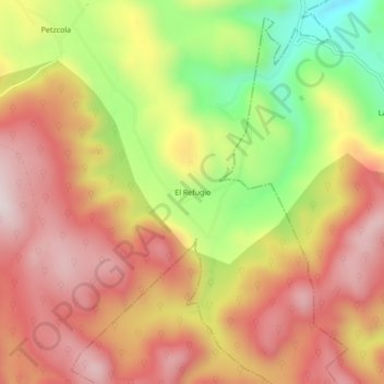
Name: El Refugio topographic map, elevation, terrain.
Location: El Refugio, Jalpan de Serra, Querétaro, México (21.19497 -99.37581 21.23497 -99.33581)
Average elevation: 3,786 ft
Minimum elevation: 2,694 ft
Maximum elevation: 4,567 ft
Other topographic maps
Click on a map to view its topography, its elevation and its terrain.
El Lindero
México > Querétaro > Jalpan de Serra
El Lindero, Jalpan de Serra, Querétaro, México
Average elevation: 2,769 ft
Barreales
México > Querétaro > Jalpan de Serra
Barreales, Jalpan de Serra, Querétaro, México
Average elevation: 4,127 ft
Tancama
México > Querétaro > Jalpan de Serra
Tancama, Jalpan de Serra, Querétaro, México
Average elevation: 3,504 ft