
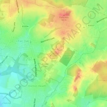
Knowle Hill topographic map
Interactive map
Click on the map to display elevation.
About this map
Name: Knowle Hill topographic map, elevation, terrain.
Average elevation: 141 ft
Minimum elevation: 56 ft
Maximum elevation: 226 ft
Other topographic maps
Click on a map to view its topography, its elevation and its terrain.
Fair Oak and Horton Heath
United Kingdom > England > Eastleigh
Fair Oak and Horton Heath, Eastleigh, Hampshire, South East, England, United Kingdom
Average elevation: 118 ft
Hamble
United Kingdom > England > Eastleigh
Hamble, Eastleigh, Hampshire, South East, England, SO32 2DB, United Kingdom
Average elevation: 75 ft
Knowle Park
United Kingdom > England > Eastleigh
Knowle Park, Fair Oak and Horton Heath, Eastleigh, Hampshire, South East, England, United Kingdom
Average elevation: 128 ft