
Sidi Mechreg topographic map
Interactive map
Click on the map to display elevation.
About this map
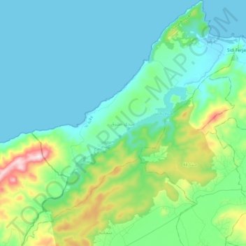
Name: Sidi Mechreg topographic map, elevation, terrain.
Location: Sidi Mechreg, Délégation Sejnane, Gouvernorat Bizerte, Tunisie (37.08503 9.07486 37.24062 9.24783)
Average elevation: 295 ft
Minimum elevation: -3 ft
Maximum elevation: 1,483 ft
Other topographic maps
Click on a map to view its topography, its elevation and its terrain.
Metline
Metline, Délégation Ras Jebel, Gouvernorat Bizerte, Tunisie
Average elevation: 230 ft
Ras Jebel
Tunisie > Gouvernorat Bizerte > Ras Jebel Nord
Ras Jebel, Ras Jebel Nord, Délégation Ras Jebel, Gouvernorat Bizerte, 7070, Tunisie
Average elevation: 203 ft
Cap Serrat
Tunisie > Gouvernorat Bizerte > Sidi Mechreg
Cap Serrat, Sidi Mechreg, Délégation Sejnane, Gouvernorat Bizerte, Tunisie
Average elevation: 59 ft
Bizerte
Tunisie > Gouvernorat Bizerte > Boubaker Bakir
Bizerte, Boubaker Bakir, Délégation Bizerte Nord, Gouvernorat Bizerte, 7000, Tunisie
Average elevation: 92 ft
Délégation Bizerte Nord
Délégation Bizerte Nord, Gouvernorat Bizerte, 7000, Tunisie
Average elevation: 82 ft