
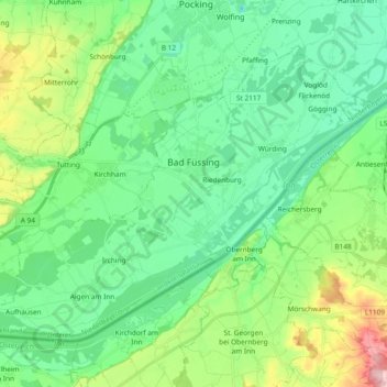
Bad Füssing topographic map
Interactive map
Click on the map to display elevation.
About this map
Name: Bad Füssing topographic map, elevation, terrain.
Location: Bad Füssing, Landkreis Passau, Beieren, 94072, Duitsland (48.29290 13.21307 48.38800 13.40037)
Average elevation: 1,122 ft
Minimum elevation: 942 ft
Maximum elevation: 1,631 ft
Other topographic maps
Click on a map to view its topography, its elevation and its terrain.
Donau
Duitsland > Beieren > Landkreis Passau > Riedl > Jochenstein
Donau, Jochenstein, Riedl, Untergriesbach, Landkreis Passau, Beieren, 94107, Duitsland
Average elevation: 1,490 ft
Hundsruck
Duitsland > Beieren > Landkreis Passau > Untergriesbach > Hundsruck
Hundsruck, Untergriesbach, Landkreis Passau, Beieren, 94136, Duitsland
Average elevation: 1,470 ft
Haarbach
Duitsland > Beieren > Landkreis Passau
Haarbach, Landkreis Passau, Beieren, 94542, Duitsland
Average elevation: 1,394 ft