
Thank you for supporting this site ❤️
Make a donation
Make a donation
Gear up for your next adventure:
As an Amazon Associate, this site earns from qualifying purchases at no extra cost to you.
Švábenice topographic map
Click on the map to display elevation.
Thank you for supporting this site ❤️
Make a donation
Make a donation
Gear up for your next adventure:
As an Amazon Associate, this site earns from qualifying purchases at no extra cost to you.
About this map
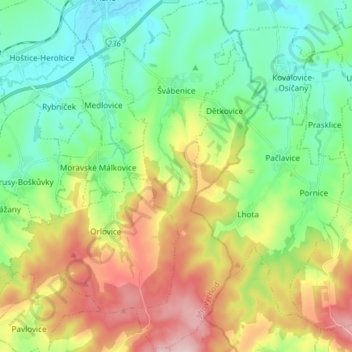
Name: Švábenice topographic map, elevation, terrain.
Location: Švábenice, okres Vyškov, Jihomoravský kraj, Southeast, Czechia (49.20565 17.10057 49.30330 17.15235)
Average elevation: 1,020 ft
Minimum elevation: 709 ft
Maximum elevation: 1,601 ft
Thank you for supporting this site ❤️
Make a donation
Make a donation
Gear up for your next adventure:
As an Amazon Associate, this site earns from qualifying purchases at no extra cost to you.
Other topographic maps
Click on a map to view its topography, its elevation and its terrain.