
The Municipal District of Callan — Thomastown topographic map
Interactive map
Click on the map to display elevation.
About this map
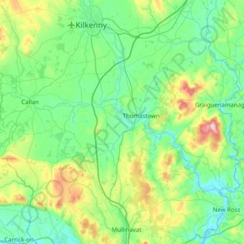
Name: The Municipal District of Callan — Thomastown topographic map, elevation, terrain.
Average elevation: 328 ft
Minimum elevation: -13 ft
Maximum elevation: 1,640 ft
Other topographic maps
Click on a map to view its topography, its elevation and its terrain.
Killeens
Killeens, Coolhill, The Municipal District of Callan — Thomastown, County Kilkenny, Leinster, Ireland
Average elevation: 207 ft
Urlingford
Urlingford, The Municipal District of Castlecomer, County Kilkenny, Leinster, Ireland
Average elevation: 410 ft
Westmoreland
Westmoreland, Aghaviller, The Municipal District of Callan — Thomastown, County Kilkenny, Leinster, Ireland
Average elevation: 440 ft
Sheastown
Sheastown, Outrath, The Municipal District of Callan — Thomastown, County Kilkenny, Leinster, Ireland
Average elevation: 187 ft
Kilkenny
Kilkenny, County Kilkenny, Leinster, Ireland
Average elevation: 203 ft
Stonyford
Stonyford, The Municipal District of Callan — Thomastown, County Kilkenny, Leinster, Ireland
Average elevation: 210 ft