
Make a donation
Gear up for your next adventure:
As an Amazon Associate, this site earns from qualifying purchases at no extra cost to you.
Coche Island topographic map
Click on the map to display elevation.
Make a donation
Gear up for your next adventure:
As an Amazon Associate, this site earns from qualifying purchases at no extra cost to you.
Coche Island
It covers an area of 55 km2 (21 sq mi) (11 km (7 mi) long by 6 km (4 mi)), with a population of about 8,200 (1999 census). The highest elevation of the island is 60 metres (197 ft) above sea level. The climate is tropical, with an average temperature of approximately 27 to 38 °C (81 to 100 °F).
Make a donation
Gear up for your next adventure:
As an Amazon Associate, this site earns from qualifying purchases at no extra cost to you.
About this map
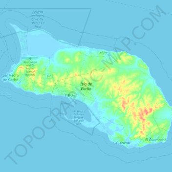
Name: Coche Island topographic map, elevation, terrain.
Average elevation: 20 ft
Minimum elevation: -7 ft
Maximum elevation: 200 ft
Make a donation
Gear up for your next adventure:
As an Amazon Associate, this site earns from qualifying purchases at no extra cost to you.