Geolocate

Province of Tambopata topographic map

Click on the map to display elevation.

About this map
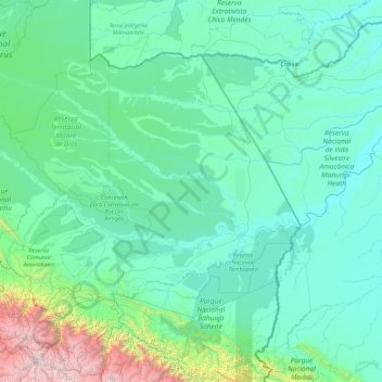
Name: Province of Tambopata topographic map, elevation, terrain.

Location: Province of Tambopata, Madre de Dios, Peru (-13.34140 -72.21766 -11.03353 -68.65199)

Average elevation: 1,880 ft

Minimum elevation: 489 ft

Maximum elevation: 19,984 ft

Other topographic maps

Click on a map to view its topography, its elevation and its terrain.

San Fracisco

Peru > Madre de Dios > Las Piedras

Average elevation: 807 ft

Puerto Maldonado

Peru > Madre de Dios

Average elevation: 656 ft

Puerto Luz

Peru > Madre de Dios > Madre de Dios

Average elevation: 886 ft

Tres Chimbadas Lake

Peru > Madre de Dios > Tambopata

Average elevation: 653 ft

Gear up for your next adventure:

🧦Hiking Socks - Comfortable socks to prevent blisters on long hikes
🪶Compact Camp Shovel - Folding shovel for campsite tasks
🚗GPS Dash Cams - Record your scenic drives through mountain passes and canyons
🪶Camping Sleeping Pad - Comfortable sleeping pad for backpacking
👟Trail Running Shoes - Lightweight shoes for trail runners

As an Amazon Associate, this site earns from qualifying purchases at no extra cost to you.