
Vynen topographic map
Interactive map
Click on the map to display elevation.
About this map
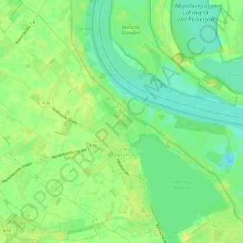
Name: Vynen topographic map, elevation, terrain.
Location: Vynen, Xanten, Kreis Wesel, Nordrhein-Westfalen, Deutschland (51.69108 6.37741 51.72442 6.43239)
Average elevation: 56 ft
Minimum elevation: 20 ft
Maximum elevation: 82 ft
Other topographic maps
Click on a map to view its topography, its elevation and its terrain.
Bislicher Insel
Deutschland > Nordrhein-Westfalen > Kreis Wesel > Xanten
Bislicher Insel, Xanten, Kreis Wesel, Nordrhein-Westfalen, Deutschland
Average elevation: 62 ft
Wardt
Deutschland > Nordrhein-Westfalen > Kreis Wesel > Xanten
Wardt, Xanten, Kreis Wesel, Nordrhein-Westfalen, 46509, Deutschland
Average elevation: 56 ft
Marienbaum
Deutschland > Nordrhein-Westfalen > Kreis Wesel > Xanten
Marienbaum, Xanten, Kreis Wesel, Nordrhein-Westfalen, Deutschland
Average elevation: 75 ft