
Carreiras topographic map
Interactive map
Click on the map to display elevation.
About this map
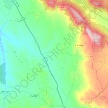
Name: Carreiras topographic map, elevation, terrain.
Average elevation: 1,667 ft
Minimum elevation: 1,115 ft
Maximum elevation: 2,717 ft
Other topographic maps
Click on a map to view its topography, its elevation and its terrain.
Ribeira de Nisa
Portugal > Alentejo > Ribeira de Nisa e Carreiras
Ribeira de Nisa, Ribeira de Nisa e Carreiras, Portalegre, Alto Alentejo, Alentejo, 7330-236 MARVÃO, Portugal
Average elevation: 1,463 ft