
Caparrosa topographic map
Interactive map
Click on the map to display elevation.
About this map
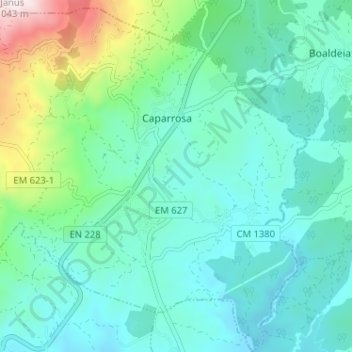
Name: Caparrosa topographic map, elevation, terrain.
Average elevation: 1,542 ft
Minimum elevation: 1,079 ft
Maximum elevation: 3,369 ft
Other topographic maps
Click on a map to view its topography, its elevation and its terrain.
Malhapão de Cima
Portugal > Centro > Tondela > Malhapão de Cima
Malhapão de Cima, Mosteirinho, U.F S.João de Monte e Mosteirinho, Tondela, Viseu, Viseu Dão-Lafões, Centro, Portugal
Average elevation: 2,523 ft
Casal de Cima
Portugal > Centro > Tondela > Casal de Cima
Casal de Cima, Vilar de Besteiros, U.F Vilar de Besteiros Monteiro de Fráguas, Tondela, Viseu, Viseu Dão-Lafões, Centro, Portugal
Average elevation: 1,122 ft