
Thuès-Entre-Valls topographic map
Interactive map
Click on the map to display elevation.
About this map
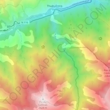
Name: Thuès-Entre-Valls topographic map, elevation, terrain.
Average elevation: 5,151 ft
Minimum elevation: 2,438 ft
Maximum elevation: 8,589 ft
Other topographic maps
Click on a map to view its topography, its elevation and its terrain.
Font-Romeu-Odeillo-Via
França > Occitânia > Pyrénées-Orientales
Font-Romeu-Odeillo-Via, Prades, Pyrénées-Orientales, Occitânia, França metropolitana, 66120, França
Average elevation: 5,686 ft
Prades
França > Occitânia > Pyrénées-Orientales > Prades
Prades, Pyrénées-Orientales, Occitânia, França metropolitana, 66500, França
Average elevation: 1,486 ft
Corsavy
França > Occitânia > Pyrénées-Orientales
Corsavy, Céret, Pyrénées-Orientales, Occitânia, França metropolitana, 66150, França
Average elevation: 3,127 ft
Caixas
França > Occitânia > Pyrénées-Orientales > Caixas
Caixas, Céret, Pyrénées-Orientales, Occitânia, França metropolitana, 66300, França
Average elevation: 1,220 ft