
Taguenzalt topographic map
Interactive map
Click on the map to display elevation.
About this map
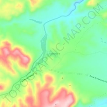
Name: Taguenzalt topographic map, elevation, terrain.
Average elevation: 4,390 ft
Minimum elevation: 4,098 ft
Maximum elevation: 4,865 ft
Other topographic maps
Click on a map to view its topography, its elevation and its terrain.
Oasis de Fint
Maroc > cercle d'Ouarzazate > Tarmigt > Oasis de Fint
Oasis de Fint, Tarmigt, caïdat de Ahl Ouarzazate, cercle d'Ouarzazate, Province de Ouarzazate, Drâa-Tafilalet, Maroc
Average elevation: 4,157 ft