
Rogaca topographic map
Interactive map
Click on the map to display elevation.
About this map
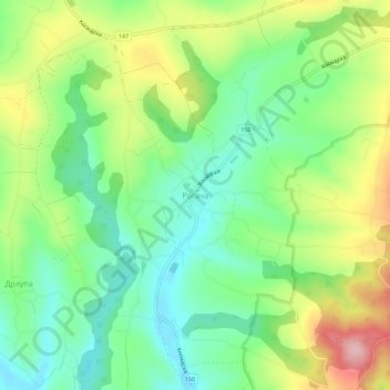
Name: Rogaca topographic map, elevation, terrain.
Average elevation: 791 ft
Minimum elevation: 548 ft
Maximum elevation: 1,198 ft
Other topographic maps
Click on a map to view its topography, its elevation and its terrain.
Stojnik
Serbia > Central Serbia > City of Belgrade > Sopot Urban Municipality
Stojnik, Sopot Urban Municipality, City of Belgrade, Central Serbia, Serbia
Average elevation: 755 ft
Ducina
Serbia > Central Serbia > City of Belgrade > Sopot Urban Municipality
Ducina, Sopot Urban Municipality, City of Belgrade, Central Serbia, Serbia
Average elevation: 725 ft