
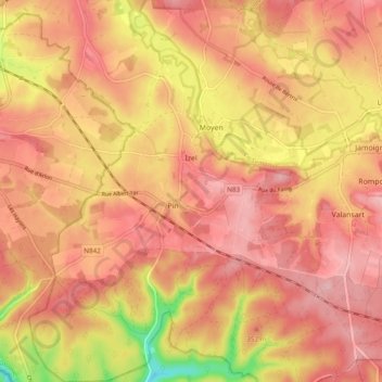
Izel topographic map
Interactive map
Click on the map to display elevation.
About this map
Name: Izel topographic map, elevation, terrain.
Location: Izel, Chiny, Virton, Luxemburg, Wallonië, 6810, België (49.65733 5.33380 49.71978 5.40267)
Average elevation: 1,089 ft
Minimum elevation: 761 ft
Maximum elevation: 1,237 ft
Other topographic maps
Click on a map to view its topography, its elevation and its terrain.
Florenville
Florenville, Virton, Luxemburg, Wallonië, België
Average elevation: 1,037 ft
Semois
België > Luxemburg > Virton > Les Bulles
Semois, Les Bulles, Chiny, Virton, Luxemburg, Wallonië, 6811, België
Average elevation: 1,089 ft
Sainte-Cécile
België > Luxemburg > Virton > Sainte-Cécile
Sainte-Cécile, Florenville, Virton, Luxemburg, Wallonië, België
Average elevation: 1,142 ft
Saint-Mard
België > Luxemburg > Virton > Virton
Saint-Mard, Virton, Luxemburg, Wallonië, 6762, België
Average elevation: 892 ft
Gérouville
België > Luxemburg > Virton > Gérouville
Gérouville, Meix-devant-Virton, Virton, Luxemburg, Wallonië, 6769, België
Average elevation: 955 ft