
Monmouthshire Canal Crumlin Branch topographic map
Interactive map
Click on the map to display elevation.
About this map
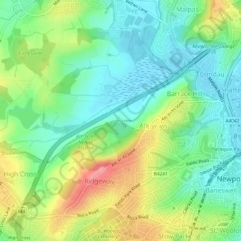
Name: Monmouthshire Canal Crumlin Branch topographic map, elevation, terrain.
Average elevation: 141 ft
Minimum elevation: 23 ft
Maximum elevation: 351 ft
Other topographic maps
Click on a map to view its topography, its elevation and its terrain.
Monmouthshire Canal Crumlin Branch
United Kingdom > Wales > Gwent > Newport
Monmouthshire Canal Crumlin Branch, Barrack Hill, Allt-Yr-Yn, Newport, Gwent, Wales, NP20 5EH, United Kingdom
Average elevation: 131 ft
Parc Seymour
United Kingdom > Wales > Gwent > Newport
Parc Seymour, Penhow, Newport, Gwent, Wales, NP26 3AB, United Kingdom
Average elevation: 351 ft
Underwood
United Kingdom > Wales > Gwent > Newport
Underwood, Newport, Gwent, Wales, NP18 2HQ, United Kingdom
Average elevation: 125 ft
Malpas
United Kingdom > Wales > Gwent > Newport
Malpas, Newport, Gwent, Wales, United Kingdom
Average elevation: 98 ft
Rhiwderin
United Kingdom > Wales > Gwent > Newport
Rhiwderin, Newport, Gwent, Wales, NP10 8RN, United Kingdom
Average elevation: 240 ft