
Vérot topographic map
Interactive map
Click on the map to display elevation.
About this map
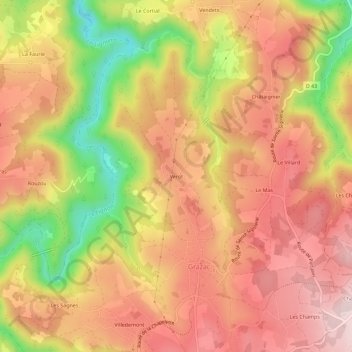
Name: Vérot topographic map, elevation, terrain.
Average elevation: 2,431 ft
Minimum elevation: 1,814 ft
Maximum elevation: 2,812 ft
Other topographic maps
Click on a map to view its topography, its elevation and its terrain.
Le Mas
France > Auvergne-Rhône-Alpes > Haute-Loire > Grazac
Le Mas, Grazac, Yssingeaux, Haute-Loire, Auvergne-Rhône-Alpes, France métropolitaine, 43200, France
Average elevation: 2,500 ft