
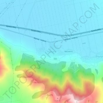
Κοιλάδα topographic map
Interactive map
Click on the map to display elevation.
About this map
Name: Κοιλάδα topographic map, elevation, terrain.
Average elevation: 2,556 ft
Minimum elevation: 2,133 ft
Maximum elevation: 4,032 ft
Other topographic maps
Click on a map to view its topography, its elevation and its terrain.
Ζαπάτιστα
Greece > Epirus and Western Macedonia > Kozani Regional Unit > Πεντάλοφος
Ζαπάτιστα, Πεντάλοφος, Voio Municipality, Kozani Regional Unit, Western Macedonia, Epirus and Western Macedonia, 500 07, Greece
Average elevation: 3,560 ft
Κοζάνη
Greece > Epirus and Western Macedonia > Kozani Regional Unit
Κοζάνη, Municipality of Kozani, Kozani Regional Unit, Western Macedonia, Epirus and Western Macedonia, 501 00, Greece
Average elevation: 2,513 ft
Ptolemaida
Greece > Epirus and Western Macedonia > Kozani Regional Unit
Ptolemaida, Eordaia Municipality, Kozani Regional Unit, Western Macedonia, Epirus and Western Macedonia, 502 00, Greece
Average elevation: 2,037 ft