
Ayegui topographic map
Interactive map
Click on the map to display elevation.
About this map
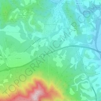
Name: Ayegui topographic map, elevation, terrain.
Location: Ayegui, Estellerria / Tierra Estella, Navarre, Espagne (42.62804 -2.07046 42.66853 -2.02549)
Average elevation: 1,831 ft
Minimum elevation: 1,329 ft
Maximum elevation: 3,376 ft
Other topographic maps
Click on a map to view its topography, its elevation and its terrain.
Estella-Lizarra
Espagne > Navarre > Estellerria / Tierra Estella
Estella-Lizarra, Estellerria / Tierra Estella, Navarre, 31200, Espagne
Average elevation: 1,686 ft
Los Arcos
Espagne > Navarre > Estellerria / Tierra Estella > Los Arcos
Los Arcos, Estellerria / Tierra Estella, Navarre, 31210, Espagne
Average elevation: 1,555 ft
Sanabria
Espagne > Navarre > Estellerria / Tierra Estella > Torralba del Río
Sanabria, Torralba del Río, Estellerria / Tierra Estella, Navarre, Espagne
Average elevation: 2,405 ft