
Les Bajaris topographic map
Interactive map
Click on the map to display elevation.
About this map
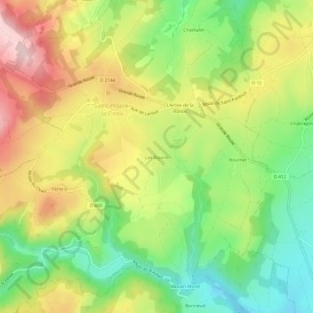
Name: Les Bajaris topographic map, elevation, terrain.
Average elevation: 1,709 ft
Minimum elevation: 1,312 ft
Maximum elevation: 2,182 ft
Other topographic maps
Click on a map to view its topography, its elevation and its terrain.
Fénérol
France > Auvergne-Rhône-Alpes > Puy-de-Dôme > Saint-Hilaire-la-Croix
Fénérol, Saint-Hilaire-la-Croix, Riom, Puy-de-Dôme, Auvergne-Rhône-Alpes, France métropolitaine, 63440, France
Average elevation: 1,788 ft