
Settle topographic map
Click on the map to display elevation.
About this map
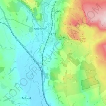
Name: Settle topographic map, elevation, terrain.
Location: Settle, North Yorkshire, England, United Kingdom (54.03599 -2.29791 54.08179 -2.20264)
Average elevation: 784 ft
Minimum elevation: 404 ft
Maximum elevation: 1,693 ft
Other topographic maps
Click on a map to view its topography, its elevation and its terrain.
Thornydale Laithe
United Kingdom > England > North Yorkshire > Craven > Calton
Average elevation: 587 ft
Milby Cut
United Kingdom > England > North Yorkshire > Harrogate > Aldborough > Milby
Average elevation: 66 ft