
Waddington topographic map
Interactive map
Click on the map to display elevation.
About this map
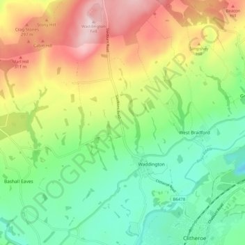
Name: Waddington topographic map, elevation, terrain.
Location: Waddington, Ribble Valley, Lancashire, England, United Kingdom (53.86998 -2.43837 53.92913 -2.39235)
Average elevation: 538 ft
Minimum elevation: 59 ft
Maximum elevation: 1,286 ft
Other topographic maps
Click on a map to view its topography, its elevation and its terrain.
Read
United Kingdom > England > Lancashire > Ribble Valley
Read, Ribble Valley, Lancashire, England, United Kingdom
Average elevation: 374 ft
Jamacia Wood
United Kingdom > England > Lancashire > Ribble Valley > Langho
Jamacia Wood, Billington and Langho, Langho, Ribble Valley, Lancashire, England, United Kingdom
Average elevation: 328 ft