
Ferme du Chesnois topographic map
Interactive map
Click on the map to display elevation.
About this map
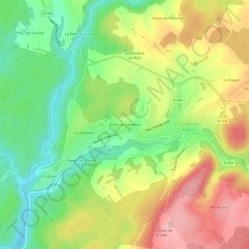
Name: Ferme du Chesnois topographic map, elevation, terrain.
Average elevation: 1,093 ft
Minimum elevation: 846 ft
Maximum elevation: 1,385 ft
Other topographic maps
Click on a map to view its topography, its elevation and its terrain.
Le Raval
France > Grand Est > Vosges > La Vôge-les-Bains
Le Raval, Bains-les-Bains, La Vôge-les-Bains, Épinal, Vosges, Grand Est, France métropolitaine, 88240, France
Average elevation: 1,224 ft
Le Pont du Coney
France > Grand Est > Vosges > La Vôge-les-Bains
Le Pont du Coney, Hautmougey, La Vôge-les-Bains, Épinal, Vosges, Grand Est, France métropolitaine, 88240, France
Average elevation: 1,056 ft
Bains-les-Bains
France > Grand Est > Vosges > La Vôge-les-Bains
Bains-les-Bains, La Vôge-les-Bains, Épinal, Vosges, Grand Est, France métropolitaine, 88240, France
Average elevation: 1,161 ft