
Saint-Léger topographic map
Interactive map
Click on the map to display elevation.
About this map
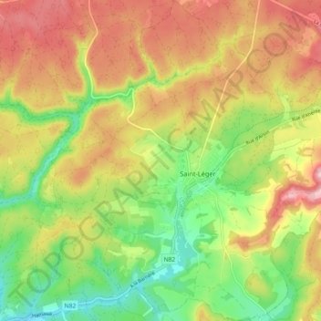
Name: Saint-Léger topographic map, elevation, terrain.
Location: Saint-Léger, Virton, Luxembourg, Wallonie, Belgique (49.58651 5.61552 49.64516 5.68776)
Average elevation: 1,001 ft
Minimum elevation: 738 ft
Maximum elevation: 1,266 ft
Other topographic maps
Click on a map to view its topography, its elevation and its terrain.
Chatillon
Belgique > Luxembourg > Virton > Saint-Léger
Chatillon, Saint-Léger, Virton, Luxembourg, Wallonie, 6747, Belgique
Average elevation: 1,115 ft