
Kallada River topographic map
Interactive map
Click on the map to display elevation.
About this map
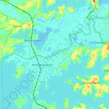
Name: Kallada River topographic map, elevation, terrain.
Location: Kallada River, Kollam, Kerala, 691001, India (8.97428 76.58520 9.02918 76.66105)
Average elevation: 26 ft
Minimum elevation: -7 ft
Maximum elevation: 125 ft
Other topographic maps
Click on a map to view its topography, its elevation and its terrain.
Chadayamangalam
Chadayamangalam, Kollam, Kerala, 691001, India
Average elevation: 226 ft
Thenmala Dam
Thenmala Dam, Kollam, Kerala, 691001, India
Average elevation: 509 ft