
Ulamış Mahallesi topographic map
Interactive map
Click on the map to display elevation.
About this map
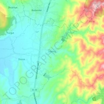
Name: Ulamış Mahallesi topographic map, elevation, terrain.
Location: Ulamış Mahallesi, Seferihisar, Izmir, Aegean Region, Turkey (38.22355 26.80799 38.26878 26.89448)
Average elevation: 381 ft
Minimum elevation: 52 ft
Maximum elevation: 1,181 ft
Other topographic maps
Click on a map to view its topography, its elevation and its terrain.
Sığacık Mahallesi
Sığacık Mahallesi, Seferihisar, Izmir, Aegean Region, Turkey
Average elevation: 72 ft