
Općina Jasenice topographic map
Interactive map
Click on the map to display elevation.
About this map
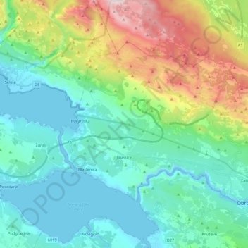
Name: Općina Jasenice topographic map, elevation, terrain.
Location: Općina Jasenice, Zadar County, 23243, Croatia (44.19836 15.52215 44.29996 15.73500)
Average elevation: 1,270 ft
Minimum elevation: -23 ft
Maximum elevation: 5,105 ft
Other topographic maps
Click on a map to view its topography, its elevation and its terrain.
Omiš
Croatia > Zadar County > Općina Preko
Omiš, Općina Preko, Zadar County, 23291, Croatia
Average elevation: 26 ft
Very small sandy beach
Croatia > Zadar County > Općina Vir > Lozice
Very small sandy beach, Lozice, Vir, Općina Vir, Zadar County, Croatia
Average elevation: 75 ft