
Espern topographic map
Interactive map
Click on the map to display elevation.
About this map
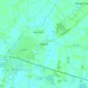
Name: Espern topographic map, elevation, terrain.
Average elevation: 10 ft
Minimum elevation: -7 ft
Maximum elevation: 26 ft
Other topographic maps
Click on a map to view its topography, its elevation and its terrain.
Leuchtenburg
Deutschland > Niedersachsen > Landkreis Ammerland > Rastede
Leuchtenburg, Rastede, Landkreis Ammerland, Niedersachsen, 26180, Deutschland
Average elevation: 56 ft
Hogenset
Deutschland > Niedersachsen > Landkreis Ammerland > Edewecht
Hogenset, Edewecht, Landkreis Ammerland, Niedersachsen, 26188, Deutschland
Average elevation: 23 ft
Jührdenerfeld
Deutschland > Niedersachsen > Landkreis Ammerland > Westerstede
Jührdenerfeld, Westerstede, Landkreis Ammerland, Niedersachsen, 26655, Deutschland
Average elevation: 36 ft