
Make a donation
Gear up for your next adventure:
As an Amazon Associate, this site earns from qualifying purchases at no extra cost to you.
Pietermaritzburg topographic map
Click on the map to display elevation.
Make a donation
Gear up for your next adventure:
As an Amazon Associate, this site earns from qualifying purchases at no extra cost to you.
About this map
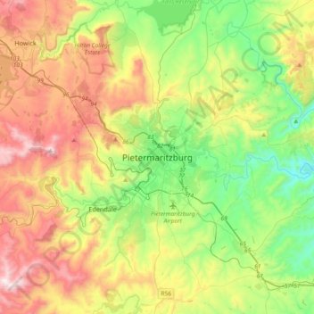
Name: Pietermaritzburg topographic map, elevation, terrain.
Average elevation: 2,799 ft
Minimum elevation: 1,417 ft
Maximum elevation: 4,954 ft
Make a donation
Gear up for your next adventure:
As an Amazon Associate, this site earns from qualifying purchases at no extra cost to you.
Other topographic maps
Click on a map to view its topography, its elevation and its terrain.
uKhahlamba / Drakensberg Park
South Africa > KwaZulu-Natal > uMgungundlovu District Municipality
The uKhahlamba-Drakensberg Park is a protected area in the KwaZulu-Natal province of South Africa, covering 2,428.13 km2 (938 sq mi), and is part of the Maloti-Drakensberg Park, a UNESCO World Heritage Site. The park includes Royal Natal National Park, a Provincial park, and covers part of the Drakensberg, an…
Average elevation: 5,781 ft
Richmond Local Municipality
South Africa > KwaZulu-Natal > uMgungundlovu District Municipality
Average elevation: 2,746 ft
uMngeni
South Africa > KwaZulu-Natal > uMgungundlovu District Municipality > uMgeni Local Municipality
Average elevation: 4,813 ft
uMngeni River
South Africa > KwaZulu-Natal > uMgungundlovu District Municipality > uMgeni Local Municipality > Howick
Average elevation: 3,399 ft
Make a donation
Gear up for your next adventure:
As an Amazon Associate, this site earns from qualifying purchases at no extra cost to you.
Mwgahumbe
South Africa > KwaZulu-Natal > uMgungundlovu District Municipality > Mkhambathini Local Municipality
Average elevation: 1,877 ft
Mpofana
South Africa > KwaZulu-Natal > uMgungundlovu District Municipality > uMgeni Local Municipality
Average elevation: 4,370 ft
Msunduzi
South Africa > KwaZulu-Natal > uMgungundlovu District Municipality
Average elevation: 3,159 ft
eChibini Tarn
South Africa > KwaZulu-Natal > uMgungundlovu District Municipality > Impendle Local Municipality
Average elevation: 7,526 ft
Make a donation
Gear up for your next adventure:
As an Amazon Associate, this site earns from qualifying purchases at no extra cost to you.
uMgeni Local Municipality
South Africa > KwaZulu-Natal > uMgungundlovu District Municipality
Average elevation: 4,377 ft
Impendle Local Municipality
South Africa > KwaZulu-Natal > uMgungundlovu District Municipality
Average elevation: 5,659 ft
Mkhambathini Local Municipality
South Africa > KwaZulu-Natal > uMgungundlovu District Municipality
Average elevation: 2,054 ft
Mkhambathini Local Municipality
South Africa > KwaZulu-Natal > uMgungundlovu District Municipality
Average elevation: 2,054 ft
Make a donation
Gear up for your next adventure:
As an Amazon Associate, this site earns from qualifying purchases at no extra cost to you.
Henley Dam
South Africa > KwaZulu-Natal > uMgungundlovu District Municipality > Msunduzi Local Municipality
Average elevation: 3,202 ft
uMshwathi Local Municipality
South Africa > KwaZulu-Natal > uMgungundlovu District Municipality
Average elevation: 2,726 ft
Mpofana Local Municipality
South Africa > KwaZulu-Natal > uMgungundlovu District Municipality
Average elevation: 4,068 ft
uMshwathi Local Municipality
South Africa > KwaZulu-Natal > uMgungundlovu District Municipality
Average elevation: 2,726 ft
Make a donation
Gear up for your next adventure:
As an Amazon Associate, this site earns from qualifying purchases at no extra cost to you.
Mkhambathini Local Municipality
South Africa > KwaZulu-Natal > uMgungundlovu District Municipality
Average elevation: 2,054 ft
uMshwathi Local Municipality
South Africa > KwaZulu-Natal > uMgungundlovu District Municipality
Average elevation: 2,726 ft
Roman Baths
South Africa > KwaZulu-Natal > uMgungundlovu District Municipality > Mpofana Local Municipality
Average elevation: 6,332 ft
uMngeni River
South Africa > KwaZulu-Natal > uMgungundlovu District Municipality > uMgeni Local Municipality > Howick
Average elevation: 3,415 ft
Make a donation
Gear up for your next adventure:
As an Amazon Associate, this site earns from qualifying purchases at no extra cost to you.
Camps Drift
South Africa > KwaZulu-Natal > uMgungundlovu District Municipality > Pietermaritzburg
Average elevation: 2,133 ft
Impendle Local Municipality
South Africa > KwaZulu-Natal > uMgungundlovu District Municipality
Average elevation: 5,659 ft
Lions River
South Africa > KwaZulu-Natal > uMgungundlovu District Municipality > uMgeni Local Municipality
Average elevation: 3,809 ft
uMngeni
South Africa > KwaZulu-Natal > uMgungundlovu District Municipality > uMgeni Local Municipality
Average elevation: 3,553 ft
Make a donation
Gear up for your next adventure:
As an Amazon Associate, this site earns from qualifying purchases at no extra cost to you.