Geolocate

Pearland topographic map

Click on the map to display elevation.

About this map
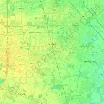
Name: Pearland topographic map, elevation, terrain.

Location: Pearland, Brazoria County, Texas, 77581, United States (29.49794 -95.44447 29.59834 -95.21143)

Average elevation: 46 ft

Minimum elevation: 13 ft

Maximum elevation: 72 ft

Brazoria County trails, hiking, mountain biking, running and outdoor activities

Other topographic maps

Click on a map to view its topography, its elevation and its terrain.
Rosharon

United States > Texas > Brazoria County

Average elevation: 52 ft

Damon

United States > Texas > Brazoria County

Average elevation: 82 ft

Damon Mound

United States > Texas > Brazoria County > Damon

Average elevation: 92 ft

Rosharon

United States > Texas > Brazoria County

Average elevation: 52 ft

Meridiana

United States > Texas > Brazoria County > Iowa Colony

Average elevation: 52 ft

Damon

United States > Texas > Brazoria County

Average elevation: 82 ft

Gear up for your next adventure:

📚USA Hiking Guide Books - Top trail guides and map books
🛠️Outdoor Gear Repair Kit - Essential tools to fix gear on the trail
🎒Day Hiking Backpack - Lightweight backpack perfect for day trips and outdoor adventures
🧭Pro Hiking Compasses - High-accuracy liquid-filled compasses for topographic orientation
🏔️Mountain Trail Maps - High‑detail maps for popular peaks

As an Amazon Associate, this site earns from qualifying purchases at no extra cost to you.