
Cirque de Gavarnie topographic map
Interactive map
Click on the map to display elevation.
About this map
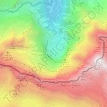
Name: Cirque de Gavarnie topographic map, elevation, terrain.
Average elevation: 7,756 ft
Minimum elevation: 4,662 ft
Maximum elevation: 10,663 ft
Other topographic maps
Click on a map to view its topography, its elevation and its terrain.
Gavarnie
Frankrijk > Occitanië > Gavarnie-Gèdre > Gavarnie
Gavarnie, Gavarnie-Gèdre, Argelès-Gazost, Hautes-Pyrénées, Occitanië, Metropolitaans Frankrijk, 65120, Frankrijk
Average elevation: 6,952 ft