
Make a donation
Gear up for your next adventure:
As an Amazon Associate, this site earns from qualifying purchases at no extra cost to you.
Cachoeira do Sul topographic map
Click on the map to display elevation.
Make a donation
Gear up for your next adventure:
As an Amazon Associate, this site earns from qualifying purchases at no extra cost to you.
Cachoeira do Sul
It is located at a latitude of 30º02'21" S and a longitude of 52º53'38" W, at an approximate elevation of 68 meters above sea level. Its population in 2020 was approximately 81,869 and its area is 3715.5 square kilometers.
Make a donation
Gear up for your next adventure:
As an Amazon Associate, this site earns from qualifying purchases at no extra cost to you.
About this map
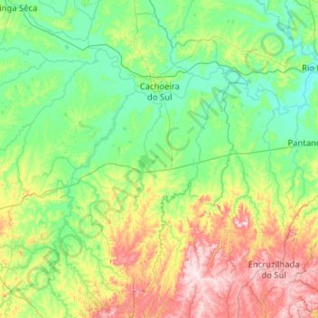
Name: Cachoeira do Sul topographic map, elevation, terrain.
Average elevation: 397 ft
Minimum elevation: 13 ft
Maximum elevation: 1,637 ft
Make a donation
Gear up for your next adventure:
As an Amazon Associate, this site earns from qualifying purchases at no extra cost to you.