
Make a donation
Gear up for your next adventure:
As an Amazon Associate, this site earns from qualifying purchases at no extra cost to you.
Mount Taylor topographic map
Click on the map to display elevation.
Make a donation
Gear up for your next adventure:
As an Amazon Associate, this site earns from qualifying purchases at no extra cost to you.
About this map
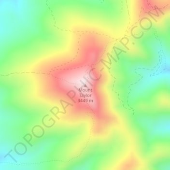
Name: Mount Taylor topographic map, elevation, terrain.
Location: Mount Taylor, Cibola County, New Mexico, United States (35.23861 -107.60845 35.23871 -107.60835)
Average elevation: 10,394 ft
Minimum elevation: 9,705 ft
Maximum elevation: 11,273 ft
Cibola County trails, hiking, mountain biking, running and outdoor activities
Make a donation
Gear up for your next adventure:
As an Amazon Associate, this site earns from qualifying purchases at no extra cost to you.
Other topographic maps
Click on a map to view its topography, its elevation and its terrain.
El Malpais National Conservation Area
United States > New Mexico > Cibola County
Average elevation: 7,402 ft