
Lorch topographic map
Click on the map to display elevation.
About this map
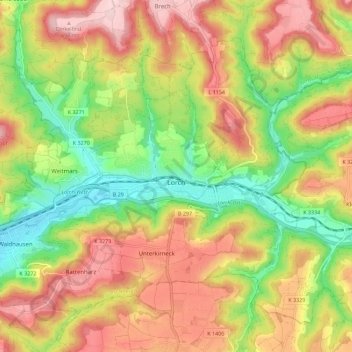
Name: Lorch topographic map, elevation, terrain.
Location: Lorch, Ostalbkreis, Baden-Württemberg, 73547, Germany (48.77034 9.61896 48.82879 9.73135)
Average elevation: 1,273 ft
Minimum elevation: 889 ft
Maximum elevation: 1,657 ft
Other topographic maps
Click on a map to view its topography, its elevation and its terrain.
Kapfenburg
Germany > Baden-Württemberg > Ostalbkreis > Lauchheim > Domäne Kapfenburg
Average elevation: 1,834 ft
Wilflingen
Germany > Baden-Württemberg > Ostalbkreis > Abtsgmünd
The main town of Abtsgmünd lies at the confluence of the Lein river into the Kocher (confluence elevation 367.4 m above sea level), predominantly on the left bank of the Kocher and left bank of the Lein. The furthest district of Untergröningen lies over 8 km west-northwest as the crow flies along two river…
Average elevation: 1,417 ft