
Esparta topographic map
Interactive map
Click on the map to display elevation.
About this map
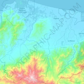
Name: Esparta topographic map, elevation, terrain.
Location: Esparta, Atlántida, Honduras (15.42699 -87.32515 15.83310 -87.12665)
Average elevation: 1,102 ft
Minimum elevation: 0 ft
Maximum elevation: 7,201 ft
Other topographic maps
Click on a map to view its topography, its elevation and its terrain.
Refugio de Vida Silvestre Bahía de Tela
Refugio de Vida Silvestre Bahía de Tela, Tela, Atlántida, Honduras
Average elevation: 3 ft
Aldea de San Juan
Aldea de San Juan, Tela, Atlántida, Honduras
Average elevation: 10 ft
Parque Nacional Jeanette Kawas
Parque Nacional Jeanette Kawas, Tela, Atlántida, Honduras
Average elevation: 72 ft
San Juan Pueblo
Honduras > Atlántida > La Masica
San Juan Pueblo, La Masica, Atlántida, Honduras
Average elevation: 213 ft
Río Papaloteca
Río Papaloteca, Jutiapa, Atlántida, Honduras
Average elevation: 377 ft
Río Cangrejal
Honduras > Atlántida > La Ceiba
Río Cangrejal, La Ceiba, Atlántida, Honduras
Average elevation: 1,309 ft