
Make a donation
Gear up for your next adventure:
As an Amazon Associate, this site earns from qualifying purchases at no extra cost to you.
Sulzbach an der Murr topographic map
Click on the map to display elevation.
Make a donation
Gear up for your next adventure:
As an Amazon Associate, this site earns from qualifying purchases at no extra cost to you.
Sulzbach an der Murr
The municipality (Gemeinde) of Sulzbach an der Murr is located in the Rems-Murr district, in the German state of Baden-Württemberg. Sulzbach's municipal area is physically located in the between the Löwenstein Hills and Murrhardt Forest, regions of the greater Swabian-Franconian Forest. Elevation above sea level in the municipal area ranges from a high of 585 meters (1,919 ft) Normalnull (NN) to a low of 259 meters (850 ft) NN.
Make a donation
Gear up for your next adventure:
As an Amazon Associate, this site earns from qualifying purchases at no extra cost to you.
About this map
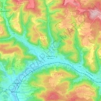
Name: Sulzbach an der Murr topographic map, elevation, terrain.
Average elevation: 1,299 ft
Minimum elevation: 830 ft
Maximum elevation: 1,978 ft
Make a donation
Gear up for your next adventure:
As an Amazon Associate, this site earns from qualifying purchases at no extra cost to you.
Other topographic maps
Click on a map to view its topography, its elevation and its terrain.
Dörnich
Germany > Baden-Württemberg > Rems-Murr-Kreis > Sulzbach an der Murr
Average elevation: 1,342 ft
Kleinhegnach
Germany > Baden-Württemberg > Rems-Murr-Kreis > Waiblingen > Neustadt
Average elevation: 909 ft