Geolocate
👉 Easily get elevation data in JSON, GeoTIFF and KML formats using Elevation API
Thank you for supporting this site ❤️
Make a donation

Dasol topographic map

Click on the map to display elevation.

About this map

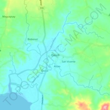
Name: Dasol topographic map, elevation, terrain.

Location: Dasol, Pangasinan, Ilocos Region, 2411, Philippines (15.95023 119.84114 16.03023 119.92114)

Average elevation: 112 ft

Minimum elevation: -3 ft

Maximum elevation: 545 ft

Other topographic maps

Click on a map to view its topography, its elevation and its terrain.

Malasiqui

Philippines > Pangasinan > Malasiqui

Average elevation: 66 ft

Santiago Island

Philippines > Pangasinan > Bolinao

Average elevation: 30 ft

Sinocalan River

Philippines > Pangasinan > San Manuel

Average elevation: 1,161 ft

Sinocalan River

Philippines > Pangasinan > Santa Barbara

Average elevation: 20 ft

San Carlos

Philippines > Pangasinan

Average elevation: 26 ft

Bugallon

Philippines > Pangasinan

Average elevation: 643 ft

Labrador

Philippines > Pangasinan

Average elevation: 148 ft

Infanta

Philippines > Pangasinan

Average elevation: 223 ft

Siapar Island

Philippines > Pangasinan

Average elevation: 7 ft

Lasud River

Philippines > Pangasinan > Abagatanen

Average elevation: 308 ft

San Roque Dam

Philippines > Pangasinan

Average elevation: 748 ft

Gear up for your next adventure:

☀️Outdoor Sunscreen - High protection sunscreen for outdoor activities
🧭GPS Watch Accessories - Bands and chargers for GPS watches
👟Men's Trail Runners - Lightweight footwear for fast-paced exploration and light hiking
🧼Biodegradable Camping Soap - Eco‑friendly soap for outdoor hygiene
🌡️Portable Weather Meter - Track weather conditions on the trail

As an Amazon Associate, this site earns from qualifying purchases at no extra cost to you.