
Gemeinde Bürs topographic map
Interactive map
Click on the map to display elevation.
About this map
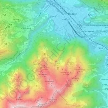
Name: Gemeinde Bürs topographic map, elevation, terrain.
Location: Gemeinde Bürs, Bezirk Bludenz, Vorarlberg, 6706, Österreich (47.08885 9.76447 47.16230 9.83198)
Average elevation: 4,121 ft
Minimum elevation: 1,785 ft
Maximum elevation: 8,543 ft
Bürs ist eine Gemeinde mit 3362 Einwohnern (Stand 1. Jänner 2020) auf 570 Metern Höhe und gehört zum Bezirk Bludenz in Vorarlberg.