
Moogerah topographic map
Interactive map
Click on the map to display elevation.
About this map
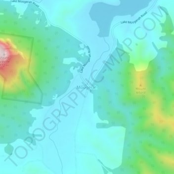
Name: Moogerah topographic map, elevation, terrain.
Location: Moogerah, Queensland, Australia (-28.10212 152.50434 -28.06212 152.54434)
Average elevation: 814 ft
Minimum elevation: 486 ft
Maximum elevation: 2,411 ft
Other topographic maps
Click on a map to view its topography, its elevation and its terrain.
Lake Moogerah
Australia > Queensland > Moogerah
Lake Moogerah, Moogerah, Scenic Rim Regional, Queensland, Australia
Average elevation: 571 ft
Mount Alford
Australia > Queensland > Moogerah
Mount Alford, Moogerah, Scenic Rim Regional, Queensland, Australia
Average elevation: 951 ft