
Dorf an der Pram topographic map
Interactive map
Click on the map to display elevation.
About this map
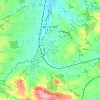
Name: Dorf an der Pram topographic map, elevation, terrain.
Location: Dorf an der Pram, Bezirk Schärding, 4751, Österreich (48.24532 13.59039 48.29304 13.65682)
Average elevation: 1,352 ft
Minimum elevation: 1,227 ft
Maximum elevation: 1,640 ft
Dorf an der Pram liegt auf 395 m Höhe im Innviertel. Die Ausdehnung beträgt von Nord nach Süd 4,9 km, von West nach Ost 5,3 km. Die Gesamtfläche beträgt 12,6 km². 7,9 % der Fläche sind bewaldet, 80,2 % der Fläche sind landwirtschaftlich genutzt.