
Arrondissement Gros Morne topographic map
Interactive map
Click on the map to display elevation.
About this map
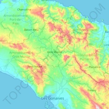
Name: Arrondissement Gros Morne topographic map, elevation, terrain.
Location: Arrondissement Gros Morne, Artibonite Department, Haiti (19.50104 -73.13629 19.81558 -72.57082)
Average elevation: 1,010 ft
Minimum elevation: -3 ft
Maximum elevation: 4,813 ft
Other topographic maps
Click on a map to view its topography, its elevation and its terrain.
Desdunes
Haiti > Artibonite Department > Commune Desdunes
Desdunes, Commune Desdunes, Arrondissement de Dessalines, Artibonite Department, Haiti
Average elevation: 20 ft